|
|
|||||||||||||||||
| Point ID: 2868 | Downloads | Plots | Site Data | Code: 05LL026 |
|
|
|||||||||||||||||
| Download | |
|---|---|
| Site Descriptor Information | Site Time Series Data |
| Link to all available data | |
| View: | Time Series | All |
| Units: | mm |
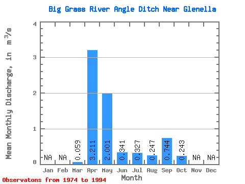
| Statistic | Jan | Feb | Mar | Apr | May | Jun | Jul | Aug | Sep | Oct | Nov | Dec | Annual |
|---|---|---|---|---|---|---|---|---|---|---|---|---|---|
| Mean | 0.06 | 3.21 | 2.00 | 0.34 | 0.33 | 0.25 | 0.74 | 0.24 | |||||
| Standard Deviation | 0.11 | 4.69 | 3.14 | 0.30 | 0.67 | 0.56 | 2.96 | 0.78 | |||||
| Min | 0.00 | 0.03 | 0.00 | 0.00 | 0.00 | 0.00 | 0.00 | 0.00 | |||||
| Max | 0.46 | 20.80 | 10.70 | 1.07 | 2.78 | 2.19 | 13.30 | 3.53 | |||||
| Coefficient of Variation | 1.94 | 1.46 | 1.57 | 0.89 | 2.05 | 2.25 | 3.98 | 3.21 |
 Return to R-Arctic Net Home Page