|
|
|||||||||||||||||
| Point ID: 2836 | Downloads | Plots | Site Data | Code: 05LJ027 |
|
|
|||||||||||||||||
| Download | |
|---|---|
| Site Descriptor Information | Site Time Series Data |
| Link to all available data | |
| View: | Time Series | All |
| Units: | mm |
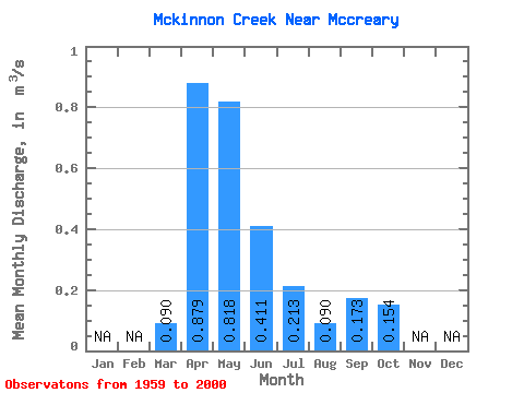
| Statistic | Jan | Feb | Mar | Apr | May | Jun | Jul | Aug | Sep | Oct | Nov | Dec | Annual |
|---|---|---|---|---|---|---|---|---|---|---|---|---|---|
| Mean | 0.09 | 0.88 | 0.82 | 0.41 | 0.21 | 0.09 | 0.17 | 0.15 | |||||
| Standard Deviation | 0.13 | 0.60 | 0.68 | 0.35 | 0.24 | 0.14 | 0.48 | 0.17 | |||||
| Min | 0.00 | 0.19 | 0.10 | 0.01 | 0.00 | 0.00 | 0.00 | 0.01 | |||||
| Max | 0.43 | 3.41 | 2.54 | 1.61 | 0.98 | 0.88 | 3.11 | 0.96 | |||||
| Coefficient of Variation | 1.42 | 0.68 | 0.83 | 0.86 | 1.12 | 1.56 | 2.77 | 1.08 |
 Return to R-Arctic Net Home Page