|
|
|||||||||||||||||
| Point ID: 2834 | Downloads | Plots | Site Data | Code: 05LJ025 |
|
|
|||||||||||||||||
| Download | |
|---|---|
| Site Descriptor Information | Site Time Series Data |
| Link to all available data | |
| View: | Time Series | All |
| Units: | mm |
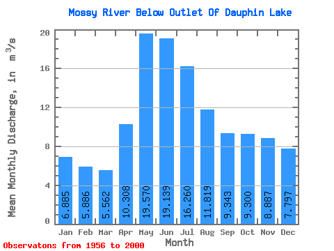
| Statistic | Jan | Feb | Mar | Apr | May | Jun | Jul | Aug | Sep | Oct | Nov | Dec | Annual |
|---|---|---|---|---|---|---|---|---|---|---|---|---|---|
| Mean | 6.88 | 5.89 | 5.56 | 10.31 | 19.57 | 19.14 | 16.26 | 11.82 | 9.34 | 9.30 | 8.89 | 7.80 | 11.30 |
| Standard Deviation | 6.74 | 5.89 | 5.40 | 8.88 | 17.57 | 18.66 | 15.67 | 12.32 | 9.93 | 9.78 | 8.60 | 7.62 | 8.43 |
| Min | 0.02 | 0.00 | 0.04 | 0.12 | 0.12 | 0.01 | 0.07 | 0.04 | 0.02 | 0.03 | 0.04 | 0.03 | 0.23 |
| Max | 27.70 | 23.90 | 20.90 | 36.40 | 62.90 | 68.60 | 54.20 | 41.10 | 33.10 | 42.00 | 38.30 | 33.50 | 30.43 |
| Coefficient of Variation | 0.98 | 1.00 | 0.97 | 0.86 | 0.90 | 0.97 | 0.96 | 1.04 | 1.06 | 1.05 | 0.97 | 0.98 | 0.74 |
 Return to R-Arctic Net Home Page