|
|
|||||||||||||||||
| Point ID: 2804 | Downloads | Plots | Site Data | Code: 05LF001 |
|
|
|||||||||||||||||
| Download | |
|---|---|
| Site Descriptor Information | Site Time Series Data |
| Link to all available data | |
| View: | Time Series | All |
| Units: | mm |
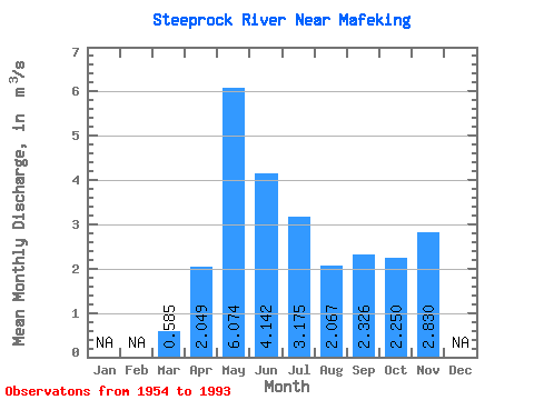
| Statistic | Jan | Feb | Mar | Apr | May | Jun | Jul | Aug | Sep | Oct | Nov | Dec | Annual |
|---|---|---|---|---|---|---|---|---|---|---|---|---|---|
| Mean | 0.58 | 2.05 | 6.07 | 4.14 | 3.17 | 2.07 | 2.33 | 2.25 | 2.83 | ||||
| Standard Deviation | 0.24 | 0.98 | 3.69 | 2.88 | 2.49 | 1.90 | 1.78 | 1.44 | |||||
| Min | 0.06 | 0.79 | 1.39 | 0.80 | 0.19 | 0.17 | 0.26 | 0.26 | 2.83 | ||||
| Max | 1.19 | 4.53 | 17.70 | 12.80 | 11.70 | 8.73 | 8.48 | 6.32 | 2.83 | ||||
| Coefficient of Variation | 0.41 | 0.48 | 0.61 | 0.69 | 0.78 | 0.92 | 0.76 | 0.64 |
 Return to R-Arctic Net Home Page