|
|
|||||||||||||||||
| Point ID: 280 | Downloads | Plots | Site Data | Code: 05BG010 |
|
|
|||||||||||||||||
| Download | |
|---|---|
| Site Descriptor Information | Site Time Series Data |
| Link to all available data | |
| View: | Time Series | All |
| Units: | mm |
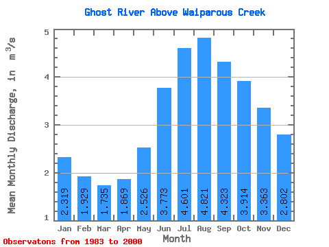
| Statistic | Jan | Feb | Mar | Apr | May | Jun | Jul | Aug | Sep | Oct | Nov | Dec | Annual |
|---|---|---|---|---|---|---|---|---|---|---|---|---|---|
| Mean | 2.32 | 1.93 | 1.73 | 1.87 | 2.53 | 3.77 | 4.60 | 4.82 | 4.32 | 3.91 | 3.36 | 2.80 | 3.18 |
| Standard Deviation | 0.37 | 0.30 | 0.24 | 0.28 | 1.93 | 2.69 | 1.97 | 1.67 | 0.92 | 0.80 | 0.60 | 0.50 | 0.75 |
| Min | 1.84 | 1.51 | 1.43 | 1.50 | 1.36 | 1.33 | 2.04 | 2.75 | 2.86 | 2.63 | 2.40 | 2.11 | 2.13 |
| Max | 3.18 | 2.58 | 2.31 | 2.49 | 9.73 | 12.30 | 8.03 | 9.79 | 6.48 | 5.91 | 4.64 | 3.83 | 4.75 |
| Coefficient of Variation | 0.16 | 0.15 | 0.14 | 0.15 | 0.76 | 0.71 | 0.43 | 0.35 | 0.21 | 0.20 | 0.18 | 0.18 | 0.23 |
 Return to R-Arctic Net Home Page