|
|
|||||||||||||||||
| Point ID: 2794 | Downloads | Plots | Site Data | Code: 05LC005 |
|
|
|||||||||||||||||
| Download | |
|---|---|
| Site Descriptor Information | Site Time Series Data |
| Link to all available data | |
| View: | Time Series | All |
| Units: | mm |
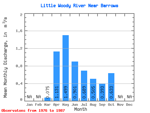
| Statistic | Jan | Feb | Mar | Apr | May | Jun | Jul | Aug | Sep | Oct | Nov | Dec | Annual |
|---|---|---|---|---|---|---|---|---|---|---|---|---|---|
| Mean | 0.07 | 1.13 | 1.50 | 0.90 | 0.69 | 0.51 | 0.39 | 0.63 | |||||
| Standard Deviation | 0.03 | 0.63 | 1.03 | 0.65 | 0.53 | 0.68 | 0.30 | 0.38 | |||||
| Min | 0.00 | 0.33 | 0.24 | 0.19 | 0.14 | 0.05 | 0.05 | 0.15 | |||||
| Max | 0.14 | 2.45 | 3.20 | 2.06 | 2.06 | 2.26 | 1.15 | 1.12 | |||||
| Coefficient of Variation | 0.45 | 0.55 | 0.69 | 0.72 | 0.77 | 1.35 | 0.77 | 0.60 |
 Return to R-Arctic Net Home Page