|
|
|||||||||||||||||
| Point ID: 2792 | Downloads | Plots | Site Data | Code: 05KL001 |
|
|
|||||||||||||||||
| Download | |
|---|---|
| Site Descriptor Information | Site Time Series Data |
| Link to all available data | |
| View: | Time Series | All |
| Units: | mm |
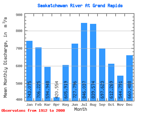
| Statistic | Jan | Feb | Mar | Apr | May | Jun | Jul | Aug | Sep | Oct | Nov | Dec | Annual |
|---|---|---|---|---|---|---|---|---|---|---|---|---|---|
| Mean | 743.08 | 706.23 | 594.95 | 420.55 | 605.92 | 727.80 | 846.04 | 839.57 | 697.62 | 612.27 | 544.79 | 660.49 | 594.92 |
| Standard Deviation | 296.42 | 304.70 | 308.30 | 189.08 | 390.06 | 516.66 | 579.19 | 559.68 | 485.27 | 391.80 | 239.90 | 248.19 | 163.39 |
| Min | 0.00 | 0.00 | 89.90 | 5.17 | 87.80 | 139.00 | 136.00 | 110.00 | 0.00 | 0.00 | 0.00 | 0.00 | 312.67 |
| Max | 1180.00 | 1190.00 | 1110.00 | 890.00 | 1570.00 | 1890.00 | 2220.00 | 2320.00 | 2140.00 | 1990.00 | 1420.00 | 1050.00 | 1076.67 |
| Coefficient of Variation | 0.40 | 0.43 | 0.52 | 0.45 | 0.64 | 0.71 | 0.69 | 0.67 | 0.70 | 0.64 | 0.44 | 0.38 | 0.28 |
 Return to R-Arctic Net Home Page