|
|
|||||||||||||||||
| Point ID: 2764 | Downloads | Plots | Site Data | Code: 10BE005 |
|
|
|||||||||||||||||
| Download | |
|---|---|
| Site Descriptor Information | Site Time Series Data |
| Link to all available data | |
| View: | Time Series | All |
| Units: | mm |
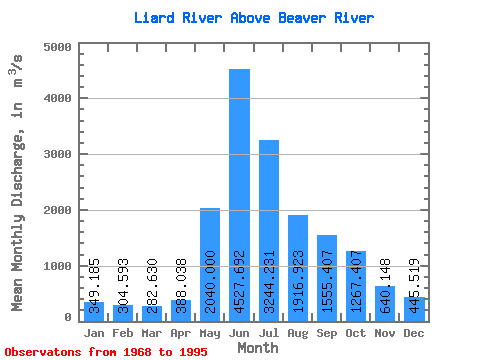
| Statistic | Jan | Feb | Mar | Apr | May | Jun | Jul | Aug | Sep | Oct | Nov | Dec | Annual |
|---|---|---|---|---|---|---|---|---|---|---|---|---|---|
| Mean | 349.19 | 304.59 | 282.63 | 388.04 | 2040.00 | 4527.69 | 3244.23 | 1916.92 | 1555.41 | 1267.41 | 640.15 | 445.52 | 1411.67 |
| Standard Deviation | 79.08 | 66.63 | 55.19 | 199.03 | 596.20 | 823.69 | 909.07 | 429.38 | 356.93 | 397.42 | 188.60 | 107.27 | 188.62 |
| Min | 234.00 | 198.00 | 180.00 | 233.00 | 1030.00 | 2520.00 | 1810.00 | 1310.00 | 896.00 | 810.00 | 404.00 | 301.00 | 987.83 |
| Max | 527.00 | 420.00 | 392.00 | 1260.00 | 3270.00 | 6560.00 | 5240.00 | 2970.00 | 2290.00 | 2300.00 | 1110.00 | 724.00 | 1880.17 |
| Coefficient of Variation | 0.23 | 0.22 | 0.20 | 0.51 | 0.29 | 0.18 | 0.28 | 0.22 | 0.23 | 0.31 | 0.29 | 0.24 | 0.13 |
 Return to R-Arctic Net Home Page