|
|
|||||||||||||||||
| Point ID: 2755 | Downloads | Plots | Site Data | Other Close Sites | Code: 10AC006 |
|
|
|||||||||||||||||
| Download | |
|---|---|
| Site Descriptor Information | Site Time Series Data |
| Link to all available data | |
| View: | Time Series | All |
| Units: | mm |
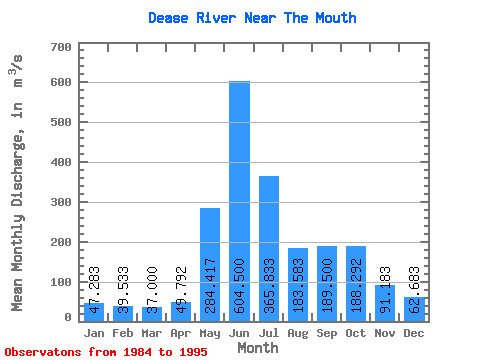
| Statistic | Jan | Feb | Mar | Apr | May | Jun | Jul | Aug | Sep | Oct | Nov | Dec | Annual |
|---|---|---|---|---|---|---|---|---|---|---|---|---|---|
| Mean | 47.28 | 39.53 | 37.00 | 49.79 | 284.42 | 604.50 | 365.83 | 183.58 | 189.50 | 188.29 | 91.18 | 62.68 | 178.63 |
| Standard Deviation | 10.24 | 7.55 | 7.83 | 15.90 | 92.10 | 165.09 | 112.56 | 32.72 | 76.20 | 95.90 | 36.93 | 19.82 | 23.88 |
| Min | 31.00 | 25.20 | 22.30 | 32.30 | 132.00 | 273.00 | 180.00 | 142.00 | 106.00 | 87.50 | 52.80 | 39.90 | 126.12 |
| Max | 67.90 | 53.10 | 50.10 | 94.60 | 447.00 | 899.00 | 582.00 | 266.00 | 333.00 | 434.00 | 186.00 | 109.00 | 202.58 |
| Coefficient of Variation | 0.22 | 0.19 | 0.21 | 0.32 | 0.32 | 0.27 | 0.31 | 0.18 | 0.40 | 0.51 | 0.41 | 0.32 | 0.13 |
| Other Close Sites | ||||||
|---|---|---|---|---|---|---|
| PointID | Latitude | Longitude | Drainage Area | Source | Name | |
| 5839 | "LIARD RIVER AT UPPER CROSSING" | 60.05 | 2067643 | Hydat | ||
 Return to R-Arctic Net Home Page