|
|
|||||||||||||||||
| Point ID: 2745 | Downloads | Plots | Site Data | Code: 09AA010 |
|
|
|||||||||||||||||
| Download | |
|---|---|
| Site Descriptor Information | Site Time Series Data |
| Link to all available data | |
| View: | Time Series | All |
| Units: | mm |
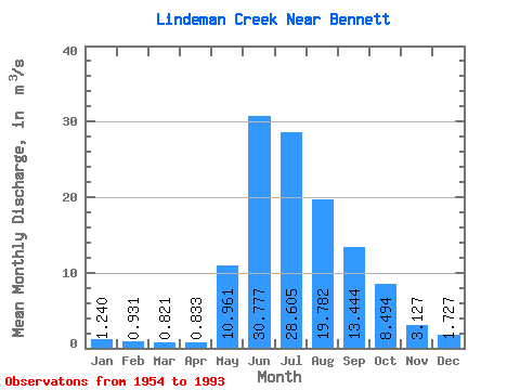
| Statistic | Jan | Feb | Mar | Apr | May | Jun | Jul | Aug | Sep | Oct | Nov | Dec | Annual |
|---|---|---|---|---|---|---|---|---|---|---|---|---|---|
| Mean | 1.24 | 0.93 | 0.82 | 0.83 | 10.96 | 30.78 | 28.61 | 19.78 | 13.44 | 8.49 | 3.13 | 1.73 | 9.96 |
| Standard Deviation | 0.40 | 0.31 | 0.57 | 0.60 | 5.79 | 5.88 | 6.04 | 3.14 | 5.38 | 3.38 | 1.51 | 0.56 | 1.10 |
| Min | 0.58 | 0.15 | 0.21 | 0.43 | 2.15 | 19.00 | 18.70 | 14.10 | 5.15 | 3.82 | 1.10 | 0.64 | 8.13 |
| Max | 2.51 | 1.49 | 3.53 | 3.31 | 27.70 | 46.60 | 41.10 | 29.80 | 31.00 | 16.50 | 7.33 | 3.14 | 12.16 |
| Coefficient of Variation | 0.32 | 0.34 | 0.70 | 0.72 | 0.53 | 0.19 | 0.21 | 0.16 | 0.40 | 0.40 | 0.48 | 0.32 | 0.11 |
 Return to R-Arctic Net Home Page