|
|
|||||||||||||||||
| Point ID: 258 | Downloads | Plots | Site Data | Code: 05BF003 |
|
|
|||||||||||||||||
| Download | |
|---|---|
| Site Descriptor Information | Site Time Series Data |
| Link to all available data | |
| View: | Time Series | All |
| Units: | mm |
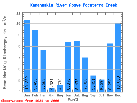
| Statistic | Jan | Feb | Mar | Apr | May | Jun | Jul | Aug | Sep | Oct | Nov | Dec | Annual |
|---|---|---|---|---|---|---|---|---|---|---|---|---|---|
| Mean | 10.28 | 9.45 | 7.66 | 4.33 | 4.58 | 8.38 | 8.48 | 7.02 | 5.43 | 5.09 | 8.25 | 10.07 | 7.33 |
| Standard Deviation | 3.51 | 3.89 | 4.24 | 2.90 | 3.40 | 8.04 | 6.88 | 4.61 | 3.18 | 2.49 | 3.57 | 2.97 | 1.14 |
| Min | 1.87 | 1.26 | 0.09 | 0.18 | 0.18 | 0.05 | 0.27 | 0.32 | 0.19 | 0.21 | 2.20 | 1.38 | 4.93 |
| Max | 17.70 | 19.60 | 17.30 | 12.50 | 14.30 | 30.80 | 26.70 | 17.20 | 14.00 | 11.50 | 16.40 | 16.60 | 9.88 |
| Coefficient of Variation | 0.34 | 0.41 | 0.55 | 0.67 | 0.74 | 0.96 | 0.81 | 0.66 | 0.59 | 0.49 | 0.43 | 0.29 | 0.15 |
 Return to R-Arctic Net Home Page