|
|
|||||||||||||||||
| Point ID: 250 | Downloads | Plots | Site Data | Code: 05BE004 |
|
|
|||||||||||||||||
| Download | |
|---|---|
| Site Descriptor Information | Site Time Series Data |
| Link to all available data | |
| View: | Time Series | All |
| Units: | mm |
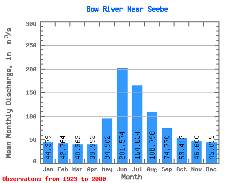
| Statistic | Jan | Feb | Mar | Apr | May | Jun | Jul | Aug | Sep | Oct | Nov | Dec | Annual |
|---|---|---|---|---|---|---|---|---|---|---|---|---|---|
| Mean | 44.38 | 42.76 | 40.36 | 39.99 | 94.90 | 201.57 | 164.83 | 108.80 | 74.77 | 53.41 | 46.60 | 45.09 | 79.80 |
| Standard Deviation | 14.14 | 13.62 | 13.55 | 11.48 | 32.73 | 64.94 | 46.94 | 23.16 | 15.44 | 10.30 | 11.20 | 13.00 | 11.74 |
| Min | 16.60 | 19.40 | 15.80 | 18.50 | 40.30 | 115.00 | 92.90 | 74.60 | 53.10 | 34.40 | 26.70 | 23.90 | 54.63 |
| Max | 69.00 | 67.70 | 70.90 | 62.20 | 194.00 | 413.00 | 295.00 | 182.00 | 123.00 | 81.00 | 69.90 | 72.20 | 105.07 |
| Coefficient of Variation | 0.32 | 0.32 | 0.34 | 0.29 | 0.34 | 0.32 | 0.28 | 0.21 | 0.21 | 0.19 | 0.24 | 0.29 | 0.15 |
 Return to R-Arctic Net Home Page