|
|
|||||||||||||||||
| Point ID: 241 | Downloads | Plots | Site Data | Code: 05BC005 |
|
|
|||||||||||||||||
| Download | |
|---|---|
| Site Descriptor Information | Site Time Series Data |
| Link to all available data | |
| View: | Time Series | All |
| Units: | mm |
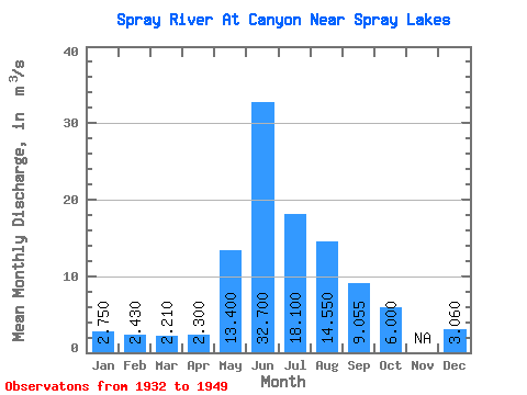
| Statistic | Jan | Feb | Mar | Apr | May | Jun | Jul | Aug | Sep | Oct | Nov | Dec | Annual |
|---|---|---|---|---|---|---|---|---|---|---|---|---|---|
| Mean | 2.75 | 2.43 | 2.21 | 2.30 | 13.40 | 32.70 | 18.10 | 14.55 | 9.05 | 6.00 | 3.06 | ||
| Standard Deviation | 3.96 | 16.55 | 4.95 | 4.46 | 0.23 | ||||||||
| Min | 2.75 | 2.43 | 2.21 | 2.30 | 10.60 | 21.00 | 14.60 | 11.40 | 8.89 | 6.00 | 3.06 | ||
| Max | 2.75 | 2.43 | 2.21 | 2.30 | 16.20 | 44.40 | 21.60 | 17.70 | 9.22 | 6.00 | 3.06 | ||
| Coefficient of Variation | 0.30 | 0.51 | 0.27 | 0.31 | 0.03 |
 Return to R-Arctic Net Home Page