|
|
|||||||||||||||||
| Point ID: 239 | Downloads | Plots | Site Data | Code: 05BC002 |
|
|
|||||||||||||||||
| Download | |
|---|---|
| Site Descriptor Information | Site Time Series Data |
| Link to all available data | |
| View: | Time Series | All |
| Units: | mm |
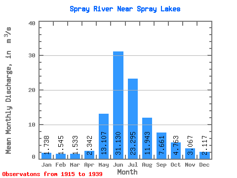
| Statistic | Jan | Feb | Mar | Apr | May | Jun | Jul | Aug | Sep | Oct | Nov | Dec | Annual |
|---|---|---|---|---|---|---|---|---|---|---|---|---|---|
| Mean | 1.74 | 1.54 | 1.53 | 2.34 | 13.11 | 31.13 | 23.30 | 11.94 | 7.66 | 4.76 | 3.07 | 2.12 | 8.54 |
| Standard Deviation | 0.49 | 0.43 | 0.39 | 1.35 | 6.14 | 7.37 | 9.85 | 3.01 | 2.35 | 1.32 | 0.92 | 0.40 | 1.45 |
| Min | 1.21 | 1.11 | 1.09 | 1.06 | 5.34 | 14.10 | 13.00 | 7.68 | 4.25 | 3.06 | 2.06 | 1.66 | 6.55 |
| Max | 3.27 | 2.92 | 2.53 | 5.96 | 27.20 | 44.20 | 57.70 | 20.70 | 13.70 | 7.73 | 5.01 | 2.93 | 10.55 |
| Coefficient of Variation | 0.28 | 0.28 | 0.25 | 0.58 | 0.47 | 0.24 | 0.42 | 0.25 | 0.31 | 0.28 | 0.30 | 0.19 | 0.17 |
 Return to R-Arctic Net Home Page