|
|
|||||||||||||||||
| Point ID: 234 | Downloads | Plots | Site Data | Code: 05BB001 |
|
|
|||||||||||||||||
| Download | |
|---|---|
| Site Descriptor Information | Site Time Series Data |
| Link to all available data | |
| View: | Time Series | All |
| Units: | mm |
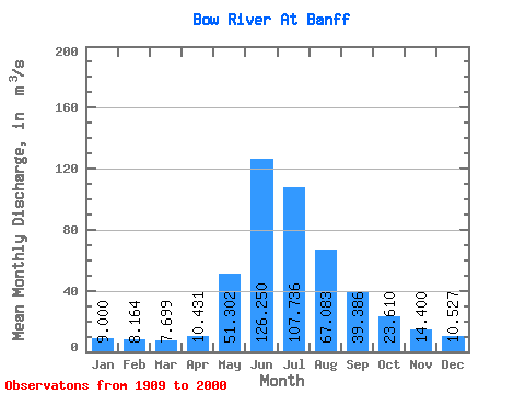
| Statistic | Jan | Feb | Mar | Apr | May | Jun | Jul | Aug | Sep | Oct | Nov | Dec | Annual |
|---|---|---|---|---|---|---|---|---|---|---|---|---|---|
| Mean | 9.00 | 8.16 | 7.70 | 10.43 | 51.30 | 126.25 | 107.74 | 67.08 | 39.39 | 23.61 | 14.40 | 10.53 | 39.43 |
| Standard Deviation | 1.21 | 1.18 | 0.90 | 3.09 | 21.43 | 31.00 | 26.64 | 12.66 | 7.42 | 4.33 | 2.45 | 1.50 | 5.14 |
| Min | 5.62 | 5.42 | 5.50 | 6.45 | 18.80 | 67.70 | 53.40 | 44.90 | 24.90 | 15.30 | 9.27 | 6.96 | 27.90 |
| Max | 12.70 | 12.20 | 9.85 | 28.90 | 115.00 | 210.00 | 184.00 | 101.00 | 71.70 | 35.20 | 23.20 | 14.70 | 50.87 |
| Coefficient of Variation | 0.14 | 0.14 | 0.12 | 0.30 | 0.42 | 0.25 | 0.25 | 0.19 | 0.19 | 0.18 | 0.17 | 0.14 | 0.13 |
 Return to R-Arctic Net Home Page