|
|
|||||||||||||||||
| Point ID: 228 | Downloads | Plots | Site Data | Code: 05BA006 |
|
|
|||||||||||||||||
| Download | |
|---|---|
| Site Descriptor Information | Site Time Series Data |
| Link to all available data | |
| View: | Time Series | All |
| Units: | mm |
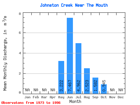
| Statistic | Jan | Feb | Mar | Apr | May | Jun | Jul | Aug | Sep | Oct | Nov | Dec | Annual |
|---|---|---|---|---|---|---|---|---|---|---|---|---|---|
| Mean | 3.22 | 7.47 | 4.96 | 2.52 | 1.58 | 0.94 | |||||||
| Standard Deviation | 1.53 | 2.32 | 1.77 | 0.92 | 0.54 | 0.18 | |||||||
| Min | 1.12 | 4.44 | 2.71 | 1.31 | 1.05 | 0.71 | |||||||
| Max | 6.58 | 12.30 | 9.40 | 5.12 | 3.52 | 1.29 | |||||||
| Coefficient of Variation | 0.47 | 0.31 | 0.36 | 0.37 | 0.34 | 0.19 |
 Return to R-Arctic Net Home Page