|
|
|||||||||||||||||
| Point ID: 227 | Downloads | Plots | Site Data | Code: 05BA005 |
|
|
|||||||||||||||||
| Download | |
|---|---|
| Site Descriptor Information | Site Time Series Data |
| Link to all available data | |
| View: | Time Series | All |
| Units: | mm |
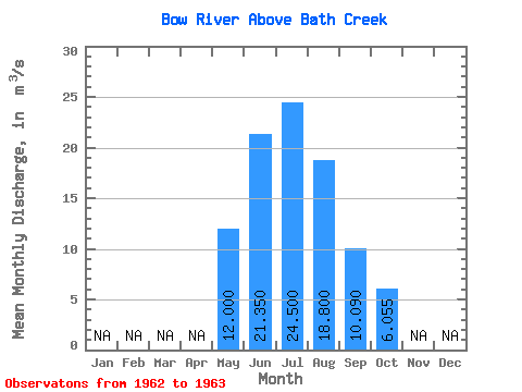
| Statistic | Jan | Feb | Mar | Apr | May | Jun | Jul | Aug | Sep | Oct | Nov | Dec | Annual |
|---|---|---|---|---|---|---|---|---|---|---|---|---|---|
| Mean | 12.00 | 21.35 | 24.50 | 18.80 | 10.09 | 6.05 | |||||||
| Standard Deviation | 6.86 | 0.85 | 0.14 | 5.53 | 2.42 | ||||||||
| Min | 12.00 | 16.50 | 23.90 | 18.70 | 6.18 | 4.34 | |||||||
| Max | 12.00 | 26.20 | 25.10 | 18.90 | 14.00 | 7.77 | |||||||
| Coefficient of Variation | 0.32 | 0.04 | 0.01 | 0.55 | 0.40 |
 Return to R-Arctic Net Home Page