|
|
|||||||||||||||||
| Point ID: 220 | Downloads | Plots | Site Data | Code: 05AJ003 |
|
|
|||||||||||||||||
| Download | |
|---|---|
| Site Descriptor Information | Site Time Series Data |
| Link to all available data | |
| View: | Time Series | All |
| Units: | mm |
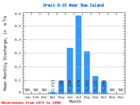
| Statistic | Jan | Feb | Mar | Apr | May | Jun | Jul | Aug | Sep | Oct | Nov | Dec | Annual |
|---|---|---|---|---|---|---|---|---|---|---|---|---|---|
| Mean | 0.01 | 0.10 | 0.34 | 0.58 | 0.31 | 0.13 | 0.09 | ||||||
| Standard Deviation | 0.11 | 0.18 | 0.20 | 0.11 | 0.11 | 0.09 | |||||||
| Min | 0.01 | 0.01 | 0.06 | 0.24 | 0.17 | 0.03 | 0.03 | ||||||
| Max | 0.01 | 0.47 | 0.60 | 1.02 | 0.55 | 0.35 | 0.36 | ||||||
| Coefficient of Variation | 1.14 | 0.52 | 0.34 | 0.34 | 0.82 | 0.92 |
 Return to R-Arctic Net Home Page