|
|
|||||||||||||||||
| Point ID: 183 | Downloads | Plots | Site Data | Code: 05AG013 |
|
|
|||||||||||||||||
| Download | |
|---|---|
| Site Descriptor Information | Site Time Series Data |
| Link to all available data | |
| View: | Time Series | All |
| Units: | mm |
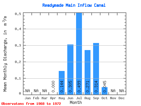
| Statistic | Jan | Feb | Mar | Apr | May | Jun | Jul | Aug | Sep | Oct | Nov | Dec | Annual |
|---|---|---|---|---|---|---|---|---|---|---|---|---|---|
| Mean | 0.00 | 0.14 | 0.30 | 0.50 | 0.27 | 0.31 | 0.04 | ||||||
| Standard Deviation | 0.00 | 0.03 | 0.12 | 0.27 | 0.05 | 0.20 | 0.02 | ||||||
| Min | 0.00 | 0.11 | 0.19 | 0.13 | 0.22 | 0.08 | 0.02 | ||||||
| Max | 0.00 | 0.19 | 0.41 | 0.72 | 0.32 | 0.55 | 0.07 | ||||||
| Coefficient of Variation | 0.23 | 0.38 | 0.55 | 0.19 | 0.63 | 0.53 |
 Return to R-Arctic Net Home Page