|
|
|||||||||||||||||
| Point ID: 179 | Downloads | Plots | Site Data | Code: 05AG008 |
|
|
|||||||||||||||||
| Download | |
|---|---|
| Site Descriptor Information | Site Time Series Data |
| Link to all available data | |
| View: | Time Series | All |
| Units: | mm |
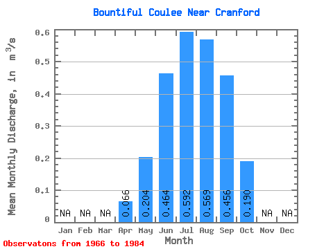
| Statistic | Jan | Feb | Mar | Apr | May | Jun | Jul | Aug | Sep | Oct | Nov | Dec | Annual |
|---|---|---|---|---|---|---|---|---|---|---|---|---|---|
| Mean | 0.07 | 0.20 | 0.46 | 0.59 | 0.57 | 0.46 | 0.19 | ||||||
| Standard Deviation | 0.17 | 0.24 | 0.14 | 0.14 | 0.15 | 0.06 | |||||||
| Min | 0.07 | 0.01 | 0.03 | 0.27 | 0.36 | 0.08 | 0.09 | ||||||
| Max | 0.07 | 0.55 | 0.89 | 0.82 | 0.85 | 0.77 | 0.29 | ||||||
| Coefficient of Variation | 0.81 | 0.51 | 0.23 | 0.26 | 0.32 | 0.30 |
 Return to R-Arctic Net Home Page