|
|
|||||||||||||||||
| Point ID: 176 | Downloads | Plots | Site Data | Code: 05AG005 |
|
|
|||||||||||||||||
| Download | |
|---|---|
| Site Descriptor Information | Site Time Series Data |
| Link to all available data | |
| View: | Time Series | All |
| Units: | mm |
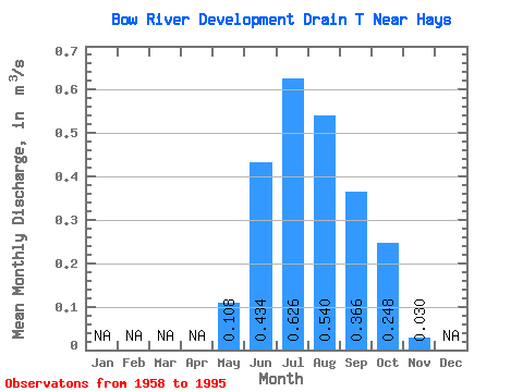
| Statistic | Jan | Feb | Mar | Apr | May | Jun | Jul | Aug | Sep | Oct | Nov | Dec | Annual |
|---|---|---|---|---|---|---|---|---|---|---|---|---|---|
| Mean | 0.11 | 0.43 | 0.63 | 0.54 | 0.37 | 0.25 | 0.03 | ||||||
| Standard Deviation | 0.13 | 0.20 | 0.20 | 0.20 | 0.17 | 0.10 | |||||||
| Min | 0.00 | 0.08 | 0.14 | 0.15 | 0.09 | 0.06 | 0.03 | ||||||
| Max | 0.48 | 0.84 | 0.94 | 0.93 | 0.77 | 0.51 | 0.03 | ||||||
| Coefficient of Variation | 1.20 | 0.46 | 0.33 | 0.37 | 0.46 | 0.42 |
 Return to R-Arctic Net Home Page