|
|
|||||||||||||||||
| Point ID: 174 | Downloads | Plots | Site Data | Code: 05AG003 |
|
|
|||||||||||||||||
| Download | |
|---|---|
| Site Descriptor Information | Site Time Series Data |
| Link to all available data | |
| View: | Time Series | All |
| Units: | mm |
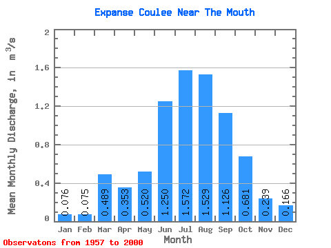
| Statistic | Jan | Feb | Mar | Apr | May | Jun | Jul | Aug | Sep | Oct | Nov | Dec | Annual |
|---|---|---|---|---|---|---|---|---|---|---|---|---|---|
| Mean | 0.08 | 0.07 | 0.49 | 0.35 | 0.52 | 1.25 | 1.57 | 1.53 | 1.13 | 0.68 | 0.24 | 0.17 | 0.47 |
| Standard Deviation | 0.05 | 0.09 | 0.67 | 0.20 | 0.37 | 0.46 | 0.48 | 0.48 | 0.38 | 0.19 | 0.10 | 0.11 | 0.08 |
| Min | 0.01 | 0.00 | 0.05 | 0.07 | 0.11 | 0.24 | 0.50 | 0.47 | 0.20 | 0.25 | 0.08 | 0.02 | 0.33 |
| Max | 0.17 | 0.26 | 2.54 | 0.73 | 1.71 | 2.14 | 2.43 | 2.22 | 1.92 | 1.04 | 0.39 | 0.35 | 0.58 |
| Coefficient of Variation | 0.63 | 1.16 | 1.37 | 0.55 | 0.71 | 0.37 | 0.30 | 0.31 | 0.33 | 0.28 | 0.42 | 0.65 | 0.17 |
 Return to R-Arctic Net Home Page