|
|
|||||||||||||||||
| Point ID: 173 | Downloads | Plots | Site Data | Code: 05AG002 |
|
|
|||||||||||||||||
| Download | |
|---|---|
| Site Descriptor Information | Site Time Series Data |
| Link to all available data | |
| View: | Time Series | All |
| Units: | mm |
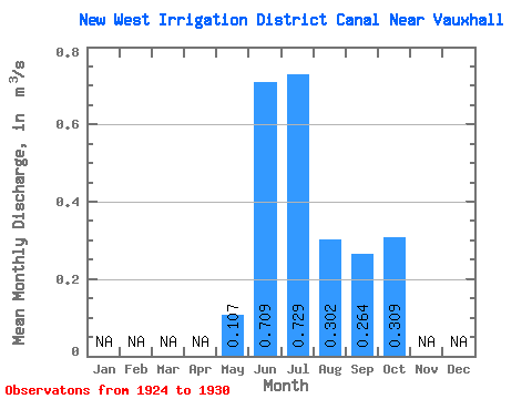
| Statistic | Jan | Feb | Mar | Apr | May | Jun | Jul | Aug | Sep | Oct | Nov | Dec | Annual |
|---|---|---|---|---|---|---|---|---|---|---|---|---|---|
| Mean | 0.11 | 0.71 | 0.73 | 0.30 | 0.26 | 0.31 | |||||||
| Standard Deviation | 0.10 | 0.43 | 0.52 | 0.08 | 0.10 | 0.38 | |||||||
| Min | 0.00 | 0.01 | 0.09 | 0.22 | 0.17 | 0.01 | |||||||
| Max | 0.27 | 1.15 | 1.38 | 0.40 | 0.45 | 0.99 | |||||||
| Coefficient of Variation | 0.91 | 0.61 | 0.71 | 0.26 | 0.38 | 1.23 |
 Return to R-Arctic Net Home Page