|
|
|||||||||||||||||
| Point ID: 161 | Downloads | Plots | Site Data | Code: 05AF010 |
|
|
|||||||||||||||||
| Download | |
|---|---|
| Site Descriptor Information | Site Time Series Data |
| Link to all available data | |
| View: | Time Series | All |
| Units: | mm |
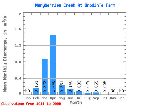
| Statistic | Jan | Feb | Mar | Apr | May | Jun | Jul | Aug | Sep | Oct | Nov | Dec | Annual |
|---|---|---|---|---|---|---|---|---|---|---|---|---|---|
| Mean | 0.15 | 0.87 | 1.45 | 0.23 | 0.14 | 0.08 | 0.03 | 0.06 | 0.01 | ||||
| Standard Deviation | 0.28 | 1.13 | 1.81 | 0.40 | 0.31 | 0.23 | 0.12 | 0.24 | 0.02 | ||||
| Min | 0.00 | 0.00 | 0.00 | 0.00 | 0.00 | 0.00 | 0.00 | 0.00 | 0.00 | ||||
| Max | 1.09 | 6.24 | 7.59 | 2.10 | 1.70 | 1.65 | 0.92 | 1.54 | 0.14 | ||||
| Coefficient of Variation | 1.85 | 1.30 | 1.25 | 1.73 | 2.24 | 2.75 | 4.13 | 4.38 | 4.35 |
 Return to R-Arctic Net Home Page