|
|
|||||||||||||||||
| Point ID: 159 | Downloads | Plots | Site Data | Code: 05AF008 |
|
|
|||||||||||||||||
| Download | |
|---|---|
| Site Descriptor Information | Site Time Series Data |
| Link to all available data | |
| View: | Time Series | All |
| Units: | mm |
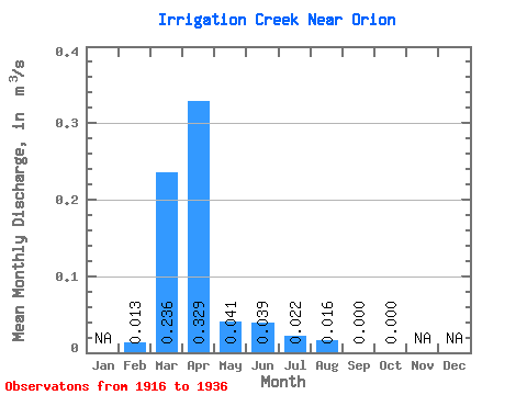
| Statistic | Jan | Feb | Mar | Apr | May | Jun | Jul | Aug | Sep | Oct | Nov | Dec | Annual |
|---|---|---|---|---|---|---|---|---|---|---|---|---|---|
| Mean | 0.01 | 0.24 | 0.33 | 0.04 | 0.04 | 0.02 | 0.02 | 0.00 | 0.00 | ||||
| Standard Deviation | 0.02 | 0.38 | 0.48 | 0.08 | 0.09 | 0.04 | 0.04 | 0.00 | 0.00 | ||||
| Min | 0.00 | 0.00 | 0.00 | 0.00 | 0.00 | 0.00 | 0.00 | 0.00 | 0.00 | ||||
| Max | 0.03 | 1.38 | 1.60 | 0.28 | 0.32 | 0.11 | 0.11 | 0.00 | 0.00 | ||||
| Coefficient of Variation | 1.41 | 1.60 | 1.47 | 1.87 | 2.34 | 1.77 | 2.65 | 2.24 |
 Return to R-Arctic Net Home Page