|
|
|||||||||||||||||
| Point ID: 157 | Downloads | Plots | Site Data | Code: 05AF006 |
|
|
|||||||||||||||||
| Download | |
|---|---|
| Site Descriptor Information | Site Time Series Data |
| Link to all available data | |
| View: | Time Series | All |
| Units: | mm |
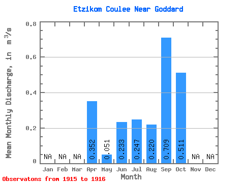
| Statistic | Jan | Feb | Mar | Apr | May | Jun | Jul | Aug | Sep | Oct | Nov | Dec | Annual |
|---|---|---|---|---|---|---|---|---|---|---|---|---|---|
| Mean | 0.35 | 0.05 | 0.23 | 0.25 | 0.22 | 0.71 | 0.51 | ||||||
| Standard Deviation | 0.29 | 0.07 | 0.31 | 0.22 | 0.13 | 0.85 | 0.50 | ||||||
| Min | 0.15 | 0.00 | 0.01 | 0.09 | 0.13 | 0.11 | 0.16 | ||||||
| Max | 0.56 | 0.10 | 0.45 | 0.40 | 0.31 | 1.31 | 0.87 | ||||||
| Coefficient of Variation | 0.82 | 1.39 | 1.32 | 0.90 | 0.59 | 1.20 | 0.98 |
 Return to R-Arctic Net Home Page