|
|
|||||||||||||||||
| Point ID: 154 | Downloads | Plots | Site Data | Code: 05AE904 |
|
|
|||||||||||||||||
| Download | |
|---|---|
| Site Descriptor Information | Site Time Series Data |
| Link to all available data | |
| View: | Time Series | All |
| Units: | mm |
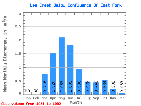
| Statistic | Jan | Feb | Mar | Apr | May | Jun | Jul | Aug | Sep | Oct | Nov | Dec | Annual |
|---|---|---|---|---|---|---|---|---|---|---|---|---|---|
| Mean | 0.75 | 1.52 | 2.09 | 1.80 | 0.94 | 0.48 | 0.45 | 0.53 | 0.20 | 0.07 | |||
| Standard Deviation | 0.58 | 0.91 | 1.45 | 1.06 | 0.52 | 0.36 | 0.30 | 0.54 | |||||
| Min | 0.15 | 0.23 | 0.42 | 0.75 | 0.28 | 0.15 | 0.13 | 0.12 | 0.20 | 0.07 | |||
| Max | 1.31 | 2.81 | 5.51 | 3.70 | 1.72 | 1.34 | 0.91 | 1.84 | 0.20 | 0.07 | |||
| Coefficient of Variation | 0.78 | 0.60 | 0.69 | 0.59 | 0.56 | 0.76 | 0.67 | 1.00 |
 Return to R-Arctic Net Home Page