|
|
|||||||||||||||||
| Point ID: 151 | Downloads | Plots | Site Data | Code: 05AE040 |
|
|
|||||||||||||||||
| Download | |
|---|---|
| Site Descriptor Information | Site Time Series Data |
| Link to all available data | |
| View: | Time Series | All |
| Units: | mm |
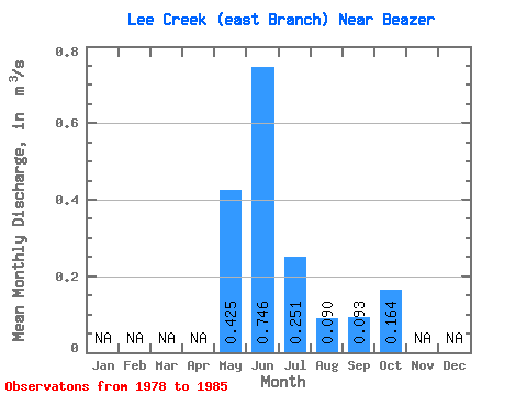
| Statistic | Jan | Feb | Mar | Apr | May | Jun | Jul | Aug | Sep | Oct | Nov | Dec | Annual |
|---|---|---|---|---|---|---|---|---|---|---|---|---|---|
| Mean | 0.42 | 0.75 | 0.25 | 0.09 | 0.09 | 0.16 | |||||||
| Standard Deviation | 0.43 | 0.13 | 0.07 | 0.10 | 0.23 | ||||||||
| Min | 0.42 | 0.24 | 0.09 | 0.02 | 0.02 | 0.03 | |||||||
| Max | 0.42 | 1.42 | 0.47 | 0.24 | 0.27 | 0.62 | |||||||
| Coefficient of Variation | 0.57 | 0.52 | 0.74 | 1.03 | 1.40 |
 Return to R-Arctic Net Home Page