|
|
|||||||||||||||||
| Point ID: 144 | Downloads | Plots | Site Data | Code: 05AE030 |
|
|
|||||||||||||||||
| Download | |
|---|---|
| Site Descriptor Information | Site Time Series Data |
| Link to all available data | |
| View: | Time Series | All |
| Units: | mm |
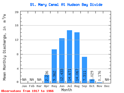
| Statistic | Jan | Feb | Mar | Apr | May | Jun | Jul | Aug | Sep | Oct | Nov | Dec | Annual |
|---|---|---|---|---|---|---|---|---|---|---|---|---|---|
| Mean | 2.24 | 9.36 | 12.43 | 14.67 | 14.07 | 7.31 | 1.03 | 0.18 | |||||
| Standard Deviation | 3.81 | 6.59 | 5.36 | 3.75 | 4.09 | 5.55 | 2.40 | 0.80 | |||||
| Min | 0.00 | 0.00 | 0.00 | 4.89 | 2.86 | 0.00 | 0.00 | 0.00 | |||||
| Max | 15.60 | 18.40 | 19.80 | 20.80 | 19.90 | 18.00 | 14.10 | 5.22 | |||||
| Coefficient of Variation | 1.70 | 0.70 | 0.43 | 0.26 | 0.29 | 0.76 | 2.34 | 4.55 |
 Return to R-Arctic Net Home Page