|
|
|||||||||||||||||
| Point ID: 140 | Downloads | Plots | Site Data | Code: 05AE026 |
|
|
|||||||||||||||||
| Download | |
|---|---|
| Site Descriptor Information | Site Time Series Data |
| Link to all available data | |
| View: | Time Series | All |
| Units: | mm |
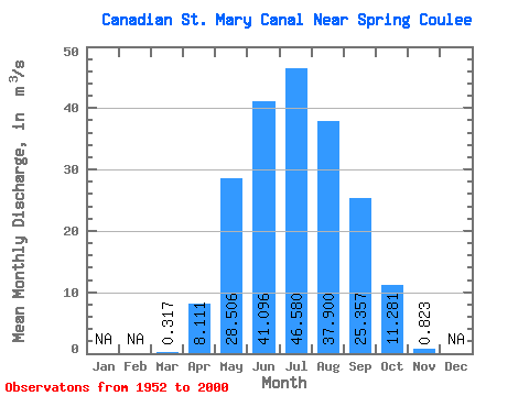
| Statistic | Jan | Feb | Mar | Apr | May | Jun | Jul | Aug | Sep | Oct | Nov | Dec | Annual |
|---|---|---|---|---|---|---|---|---|---|---|---|---|---|
| Mean | 0.32 | 8.11 | 28.51 | 41.10 | 46.58 | 37.90 | 25.36 | 11.28 | 0.82 | ||||
| Standard Deviation | 0.89 | 13.34 | 21.49 | 21.17 | 20.45 | 13.69 | 13.99 | 7.73 | 3.49 | ||||
| Min | 0.00 | 0.00 | 0.02 | 0.14 | 6.46 | 5.81 | 1.25 | 0.10 | 0.00 | ||||
| Max | 2.51 | 50.00 | 84.00 | 82.50 | 85.60 | 67.60 | 53.30 | 39.80 | 14.80 | ||||
| Coefficient of Variation | 2.79 | 1.64 | 0.75 | 0.52 | 0.44 | 0.36 | 0.55 | 0.69 | 4.24 |
 Return to R-Arctic Net Home Page