|
|
|||||||||||||||||
| Point ID: 137 | Downloads | Plots | Site Data | Code: 05AE021 |
|
|
|||||||||||||||||
| Download | |
|---|---|
| Site Descriptor Information | Site Time Series Data |
| Link to all available data | |
| View: | Time Series | All |
| Units: | mm |
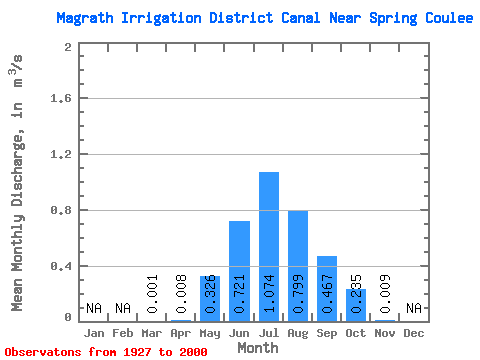
| Statistic | Jan | Feb | Mar | Apr | May | Jun | Jul | Aug | Sep | Oct | Nov | Dec | Annual |
|---|---|---|---|---|---|---|---|---|---|---|---|---|---|
| Mean | 0.00 | 0.01 | 0.33 | 0.72 | 1.07 | 0.80 | 0.47 | 0.23 | 0.01 | ||||
| Standard Deviation | 0.00 | 0.03 | 0.41 | 0.55 | 0.66 | 0.38 | 0.29 | 0.19 | 0.01 | ||||
| Min | 0.00 | 0.00 | 0.00 | 0.00 | 0.05 | 0.15 | 0.00 | 0.00 | 0.00 | ||||
| Max | 0.00 | 0.17 | 1.60 | 2.18 | 2.95 | 1.81 | 1.21 | 1.03 | 0.01 | ||||
| Coefficient of Variation | 1.73 | 3.55 | 1.24 | 0.77 | 0.62 | 0.48 | 0.62 | 0.80 | 0.58 |
 Return to R-Arctic Net Home Page