|
|
|||||||||||||||||
| Point ID: 134 | Downloads | Plots | Site Data | Code: 05AE016 |
|
|
|||||||||||||||||
| Download | |
|---|---|
| Site Descriptor Information | Site Time Series Data |
| Link to all available data | |
| View: | Time Series | All |
| Units: | mm |
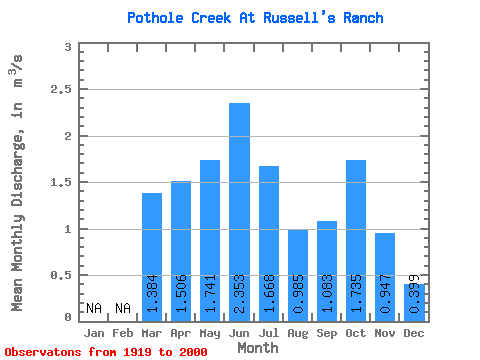
| Statistic | Jan | Feb | Mar | Apr | May | Jun | Jul | Aug | Sep | Oct | Nov | Dec | Annual |
|---|---|---|---|---|---|---|---|---|---|---|---|---|---|
| Mean | 1.38 | 1.51 | 1.74 | 2.35 | 1.67 | 0.98 | 1.08 | 1.73 | 0.95 | 0.40 | |||
| Standard Deviation | 1.91 | 1.24 | 1.85 | 3.35 | 2.76 | 1.85 | 2.13 | 3.17 | 1.01 | 0.39 | |||
| Min | 0.01 | 0.13 | 0.02 | 0.17 | 0.03 | 0.00 | 0.01 | 0.00 | 0.08 | 0.12 | |||
| Max | 8.66 | 5.70 | 10.10 | 23.00 | 21.30 | 14.20 | 16.10 | 23.40 | 3.59 | 0.68 | |||
| Coefficient of Variation | 1.38 | 0.83 | 1.07 | 1.43 | 1.65 | 1.88 | 1.97 | 1.82 | 1.06 | 0.98 |
 Return to R-Arctic Net Home Page