|
|
|||||||||||||||||
| Point ID: 130 | Downloads | Plots | Site Data | Code: 05AE011 |
|
|
|||||||||||||||||
| Download | |
|---|---|
| Site Descriptor Information | Site Time Series Data |
| Link to all available data | |
| View: | Time Series | All |
| Units: | mm |
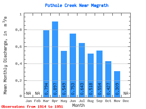
| Statistic | Jan | Feb | Mar | Apr | May | Jun | Jul | Aug | Sep | Oct | Nov | Dec | Annual |
|---|---|---|---|---|---|---|---|---|---|---|---|---|---|
| Mean | 0.79 | 0.90 | 0.55 | 0.75 | 0.64 | 0.52 | 0.55 | 0.43 | 0.31 | ||||
| Standard Deviation | 1.06 | 1.03 | 1.09 | 1.83 | 1.87 | 1.47 | 1.25 | 1.13 | 0.14 | ||||
| Min | 0.01 | 0.00 | 0.00 | 0.00 | 0.00 | 0.00 | 0.00 | 0.00 | 0.21 | ||||
| Max | 4.00 | 3.79 | 5.65 | 10.30 | 9.27 | 6.42 | 5.46 | 4.87 | 0.41 | ||||
| Coefficient of Variation | 1.34 | 1.15 | 1.98 | 2.43 | 2.91 | 2.84 | 2.25 | 2.63 | 0.45 |
 Return to R-Arctic Net Home Page