|
|
|||||||||||||||||
| Point ID: 116 | Downloads | Plots | Site Data | Code: 05AD041 |
|
|
|||||||||||||||||
| Download | |
|---|---|
| Site Descriptor Information | Site Time Series Data |
| Link to all available data | |
| View: | Time Series | All |
| Units: | mm |
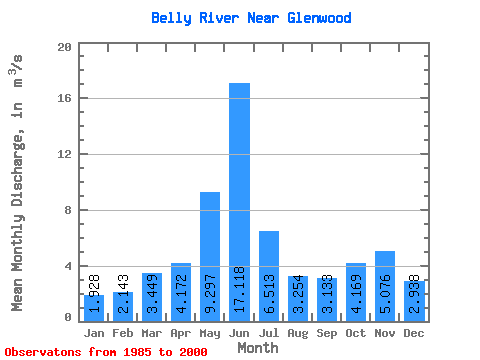
| Statistic | Jan | Feb | Mar | Apr | May | Jun | Jul | Aug | Sep | Oct | Nov | Dec | Annual |
|---|---|---|---|---|---|---|---|---|---|---|---|---|---|
| Mean | 1.93 | 2.14 | 3.45 | 4.17 | 9.30 | 17.12 | 6.51 | 3.25 | 3.13 | 4.17 | 5.08 | 2.94 | 5.36 |
| Standard Deviation | 0.58 | 1.19 | 1.94 | 2.95 | 7.12 | 17.99 | 6.66 | 2.70 | 2.83 | 1.91 | 3.65 | 1.92 | 2.83 |
| Min | 1.07 | 1.01 | 0.67 | 0.85 | 1.26 | 1.16 | 0.87 | 0.80 | 0.90 | 1.90 | 1.72 | 1.51 | 1.66 |
| Max | 3.18 | 5.51 | 7.84 | 11.20 | 20.40 | 63.20 | 23.00 | 10.00 | 10.90 | 9.53 | 11.80 | 8.81 | 12.08 |
| Coefficient of Variation | 0.30 | 0.55 | 0.56 | 0.71 | 0.77 | 1.05 | 1.02 | 0.83 | 0.90 | 0.46 | 0.72 | 0.66 | 0.53 |
 Return to R-Arctic Net Home Page