|
|
|||||||||||||||||
| Point ID: 113 | Downloads | Plots | Site Data | Code: 05AD037 |
|
|
|||||||||||||||||
| Download | |
|---|---|
| Site Descriptor Information | Site Time Series Data |
| Link to all available data | |
| View: | Time Series | All |
| Units: | mm |
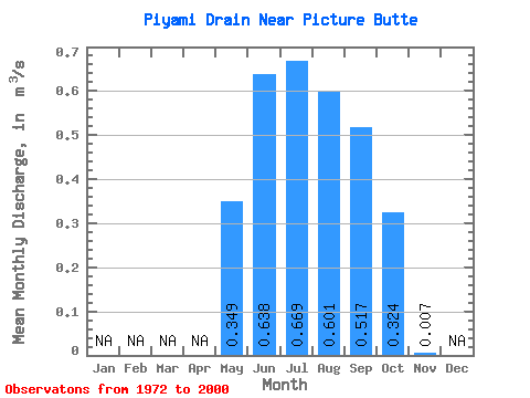
| Statistic | Jan | Feb | Mar | Apr | May | Jun | Jul | Aug | Sep | Oct | Nov | Dec | Annual |
|---|---|---|---|---|---|---|---|---|---|---|---|---|---|
| Mean | 0.35 | 0.64 | 0.67 | 0.60 | 0.52 | 0.32 | 0.01 | ||||||
| Standard Deviation | 0.25 | 0.23 | 0.22 | 0.20 | 0.20 | 0.12 | |||||||
| Min | 0.03 | 0.07 | 0.15 | 0.20 | 0.17 | 0.05 | 0.01 | ||||||
| Max | 0.85 | 1.15 | 1.08 | 1.00 | 0.93 | 0.55 | 0.01 | ||||||
| Coefficient of Variation | 0.71 | 0.36 | 0.33 | 0.34 | 0.40 | 0.39 |
 Return to R-Arctic Net Home Page