|
|
|||||||||||||||||
| Point ID: 112 | Downloads | Plots | Site Data | Code: 05AD036 |
|
|
|||||||||||||||||
| Download | |
|---|---|
| Site Descriptor Information | Site Time Series Data |
| Link to all available data | |
| View: | Time Series | All |
| Units: | mm |
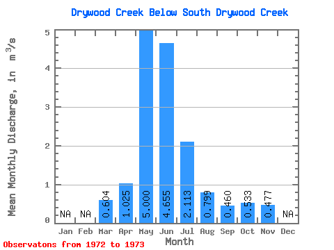
| Statistic | Jan | Feb | Mar | Apr | May | Jun | Jul | Aug | Sep | Oct | Nov | Dec | Annual |
|---|---|---|---|---|---|---|---|---|---|---|---|---|---|
| Mean | 0.60 | 1.02 | 5.00 | 4.66 | 2.11 | 0.80 | 0.46 | 0.53 | 0.48 | ||||
| Standard Deviation | 0.46 | 0.66 | 2.77 | 2.95 | 2.03 | 0.67 | 0.30 | 0.43 | |||||
| Min | 0.28 | 0.56 | 3.04 | 2.57 | 0.68 | 0.33 | 0.24 | 0.23 | 0.48 | ||||
| Max | 0.93 | 1.49 | 6.96 | 6.74 | 3.55 | 1.27 | 0.68 | 0.84 | 0.48 | ||||
| Coefficient of Variation | 0.77 | 0.64 | 0.55 | 0.63 | 0.96 | 0.83 | 0.66 | 0.81 |
 Return to R-Arctic Net Home Page