|
|
|||||||||||||||||
| Point ID: 10 | Downloads | Plots | Site Data | Code: 05AA010 |
|
|
|||||||||||||||||
| Download | |
|---|---|
| Site Descriptor Information | Site Time Series Data |
| Link to all available data | |
| View: | Time Series | All |
| Units: | mm |
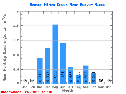
| Statistic | Jan | Feb | Mar | Apr | May | Jun | Jul | Aug | Sep | Oct | Nov | Dec | Annual |
|---|---|---|---|---|---|---|---|---|---|---|---|---|---|
| Mean | 0.71 | 0.97 | 1.63 | 1.12 | 0.47 | 0.24 | 0.51 | 0.30 | |||||
| Standard Deviation | 0.40 | 0.84 | 0.78 | 0.34 | 0.15 | 0.88 | 0.20 | ||||||
| Min | 0.71 | 0.60 | 0.67 | 0.36 | 0.17 | 0.09 | 0.07 | 0.10 | |||||
| Max | 0.71 | 1.39 | 2.79 | 2.16 | 0.95 | 0.46 | 2.28 | 0.58 | |||||
| Coefficient of Variation | 0.41 | 0.52 | 0.69 | 0.72 | 0.63 | 1.73 | 0.66 |
 Return to R-Arctic Net Home Page