|
|
|||||||||||||||||
| Point ID: 1 | Downloads | Plots | Site Data | Code: 05AA001 |
|
|
|||||||||||||||||
| Download | |
|---|---|
| Site Descriptor Information | Site Time Series Data |
| Link to all available data | |
| View: | Time Series | All |
| Units: | mm |
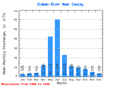
| Statistic | Jan | Feb | Mar | Apr | May | Jun | Jul | Aug | Sep | Oct | Nov | Dec | Annual |
|---|---|---|---|---|---|---|---|---|---|---|---|---|---|
| Mean | 2.93 | 3.54 | 4.06 | 12.27 | 42.17 | 60.34 | 23.01 | 11.34 | 9.73 | 8.04 | 5.20 | 3.39 | 15.77 |
| Standard Deviation | 1.24 | 3.84 | 2.39 | 5.53 | 11.53 | 26.48 | 12.79 | 5.94 | 8.96 | 5.42 | 2.54 | 1.20 | 4.43 |
| Min | 1.21 | 1.20 | 1.74 | 2.59 | 13.30 | 24.40 | 9.16 | 4.71 | 3.21 | 3.22 | 2.29 | 1.45 | 10.01 |
| Max | 7.46 | 21.70 | 12.10 | 23.00 | 65.30 | 129.00 | 52.60 | 22.90 | 39.20 | 22.30 | 10.60 | 5.69 | 24.61 |
| Coefficient of Variation | 0.42 | 1.08 | 0.59 | 0.45 | 0.27 | 0.44 | 0.56 | 0.52 | 0.92 | 0.67 | 0.49 | 0.35 | 0.28 |
 Return to R-Arctic Net Home Page