|
|
|||||||||||||||||
| Point ID: 9737 | Downloads | Plots | Site Data | Code: 05054000 |
|
|
|||||||||||||||||
| Download | |
|---|---|
| Site Descriptor Information | Site Time Series Data |
| Link to all available data | |
| View: | Time Series | All |
| Units: | m3/s |
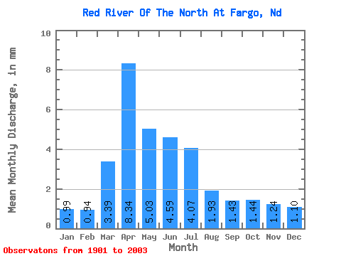
| Statistic | Jan | Feb | Mar | Apr | May | Jun | Jul | Aug | Sep | Oct | Nov | Dec | Annual |
|---|---|---|---|---|---|---|---|---|---|---|---|---|---|
| Mean | 0.99 | 0.95 | 3.39 | 8.34 | 5.03 | 4.58 | 4.07 | 1.94 | 1.43 | 1.44 | 1.24 | 1.10 | 34.49 |
| Standard Deviation | 0.81 | 0.84 | 3.68 | 10.96 | 4.62 | 3.82 | 4.76 | 2.23 | 1.62 | 1.36 | 1.02 | 0.97 | 27.77 |
| Min | 0.00 | 0.00 | 0.12 | 0.42 | 0.04 | 0.01 | 0.00 | 0.00 | 0.00 | 0.00 | 0.00 | 0.00 | 0.81 |
| Max | 3.19 | 5.31 | 20.33 | 74.66 | 23.10 | 21.34 | 24.51 | 14.18 | 9.50 | 7.50 | 3.93 | 5.43 | 137.82 |
| Coefficient of Variation | 0.81 | 0.89 | 1.08 | 1.31 | 0.92 | 0.83 | 1.17 | 1.15 | 1.14 | 0.94 | 0.82 | 0.88 | 0.81 |
 Return to R-Arctic Net Home Page