|
|
|||||||||||||||||
| Point ID: 9736 | Downloads | Plots | Site Data | Code: 05117500 |
|
|
|||||||||||||||||
| Download | |
|---|---|
| Site Descriptor Information | Site Time Series Data |
| Link to all available data | |
| View: | Time Series | All |
| Units: | m3/s |
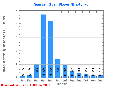
| Statistic | Jan | Feb | Mar | Apr | May | Jun | Jul | Aug | Sep | Oct | Nov | Dec | Annual |
|---|---|---|---|---|---|---|---|---|---|---|---|---|---|
| Mean | 0.06 | 0.07 | 0.38 | 1.73 | 1.55 | 0.52 | 0.34 | 0.17 | 0.12 | 0.09 | 0.07 | 0.06 | 5.16 |
| Standard Deviation | 0.10 | 0.14 | 0.59 | 2.55 | 2.78 | 0.73 | 0.54 | 0.24 | 0.24 | 0.13 | 0.09 | 0.09 | 6.47 |
| Min | 0.00 | 0.00 | 0.00 | 0.00 | 0.00 | 0.00 | 0.00 | 0.00 | 0.00 | 0.00 | 0.00 | 0.00 | 0.04 |
| Max | 0.47 | 1.00 | 3.51 | 16.60 | 13.58 | 3.75 | 3.85 | 1.33 | 2.00 | 0.73 | 0.42 | 0.45 | 35.10 |
| Coefficient of Variation | 1.69 | 2.04 | 1.55 | 1.48 | 1.80 | 1.42 | 1.58 | 1.41 | 1.93 | 1.40 | 1.25 | 1.43 | 1.25 |
 Return to R-Arctic Net Home Page