|
|
|||||||||||||||||
| Point ID: 9731 | Downloads | Plots | Site Data | Code: 05131500 |
|
|
|||||||||||||||||
| Download | |
|---|---|
| Site Descriptor Information | Site Time Series Data |
| Link to all available data | |
| View: | Time Series | All |
| Units: | m3/s |
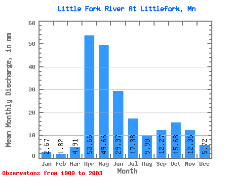
| Statistic | Jan | Feb | Mar | Apr | May | Jun | Jul | Aug | Sep | Oct | Nov | Dec | Annual |
|---|---|---|---|---|---|---|---|---|---|---|---|---|---|
| Mean | 2.67 | 1.83 | 4.91 | 53.66 | 49.65 | 29.38 | 17.38 | 9.97 | 12.27 | 15.68 | 12.36 | 5.72 | 219.18 |
| Standard Deviation | 1.50 | 0.85 | 7.32 | 30.66 | 31.37 | 20.49 | 14.14 | 9.83 | 13.49 | 15.47 | 10.28 | 3.91 | 77.12 |
| Min | 0.76 | 0.67 | 0.88 | 4.92 | 3.02 | 3.07 | 1.31 | 0.60 | 0.49 | 0.76 | 1.03 | 0.92 | 65.87 |
| Max | 8.31 | 4.29 | 52.67 | 142.05 | 212.45 | 92.60 | 63.49 | 46.69 | 87.53 | 77.56 | 51.35 | 20.67 | 384.47 |
| Coefficient of Variation | 0.56 | 0.46 | 1.49 | 0.57 | 0.63 | 0.70 | 0.81 | 0.98 | 1.10 | 0.99 | 0.83 | 0.68 | 0.35 |
 Return to R-Arctic Net Home Page