|
|
|||||||||||||||||
| Point ID: 9705 | Downloads | Plots | Site Data | Code: 05051500 |
|
|
|||||||||||||||||
| Download | |
|---|---|
| Site Descriptor Information | Site Time Series Data |
| Link to all available data | |
| View: | Time Series | All |
| Units: | m3/s |
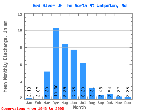
| Statistic | Jan | Feb | Mar | Apr | May | Jun | Jul | Aug | Sep | Oct | Nov | Dec | Annual |
|---|---|---|---|---|---|---|---|---|---|---|---|---|---|
| Mean | 2.13 | 2.09 | 5.20 | 10.30 | 8.39 | 7.75 | 6.20 | 3.31 | 2.48 | 2.54 | 2.32 | 2.25 | 54.72 |
| Standard Deviation | 1.26 | 1.25 | 3.82 | 10.21 | 5.56 | 4.86 | 4.50 | 3.07 | 2.51 | 2.06 | 1.56 | 1.50 | 31.29 |
| Min | 0.06 | 0.12 | 0.61 | 0.97 | 0.16 | 0.64 | 0.48 | 0.39 | 0.01 | 0.04 | 0.05 | 0.05 | 11.12 |
| Max | 4.95 | 5.78 | 19.20 | 61.60 | 24.41 | 21.07 | 20.35 | 18.23 | 15.18 | 11.67 | 6.73 | 7.06 | 143.55 |
| Coefficient of Variation | 0.59 | 0.60 | 0.73 | 0.99 | 0.66 | 0.63 | 0.73 | 0.93 | 1.01 | 0.81 | 0.67 | 0.67 | 0.57 |
 Return to R-Arctic Net Home Page