|
|
|||||||||||||||||
| Point ID: 9695 | Downloads | Plots | Site Data | Code: 05104500 |
|
|
|||||||||||||||||
| Download | |
|---|---|
| Site Descriptor Information | Site Time Series Data |
| Link to all available data | |
| View: | Time Series | All |
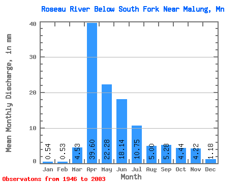
| Units: | m3/s |
| Statistic | Jan | Feb | Mar | Apr | May | Jun | Jul | Aug | Sep | Oct | Nov | Dec | Annual |
|---|---|---|---|---|---|---|---|---|---|---|---|---|---|
| Mean | 0.54 | 0.54 | 4.53 | 39.60 | 22.28 | 18.14 | 10.76 | 5.00 | 5.28 | 4.44 | 4.22 | 1.18 | 118.16 |
| Standard Deviation | 0.36 | 0.95 | 6.75 | 34.59 | 22.89 | 28.53 | 14.83 | 10.93 | 9.09 | 6.00 | 8.11 | 0.98 | 73.17 |
| Min | 0.00 | 0.00 | 0.06 | 0.37 | 0.60 | 0.28 | 0.01 | 0.00 | 0.00 | 0.00 | 0.01 | 0.00 | 5.75 |
| Max | 1.51 | 6.30 | 35.71 | 134.12 | 108.23 | 183.67 | 78.43 | 61.00 | 46.82 | 23.92 | 55.87 | 4.47 | 259.99 |
| Coefficient of Variation | 0.67 | 1.78 | 1.49 | 0.87 | 1.03 | 1.57 | 1.38 | 2.19 | 1.72 | 1.35 | 1.92 | 0.83 | 0.62 |
 Return to R-Arctic Net Home Page