|
|
|||||||||||||||||
| Point ID: 9694 | Downloads | Plots | Site Data | Code: 05061000 |
|
|
|||||||||||||||||
| Download | |
|---|---|
| Site Descriptor Information | Site Time Series Data |
| Link to all available data | |
| View: | Time Series | All |
| Units: | m3/s |
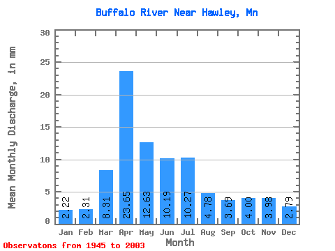
| Statistic | Jan | Feb | Mar | Apr | May | Jun | Jul | Aug | Sep | Oct | Nov | Dec | Annual |
|---|---|---|---|---|---|---|---|---|---|---|---|---|---|
| Mean | 2.22 | 2.33 | 8.31 | 23.65 | 12.63 | 10.19 | 10.27 | 4.78 | 3.69 | 4.00 | 3.98 | 2.79 | 89.94 |
| Standard Deviation | 1.30 | 2.15 | 7.88 | 18.46 | 8.84 | 10.09 | 13.72 | 7.60 | 3.41 | 3.12 | 3.99 | 2.04 | 46.29 |
| Min | 0.90 | 0.81 | 1.35 | 2.90 | 1.93 | 1.11 | 0.91 | 0.53 | 0.74 | 1.04 | 1.06 | 0.95 | 24.67 |
| Max | 6.33 | 13.96 | 39.13 | 90.34 | 34.52 | 51.38 | 70.63 | 42.53 | 16.71 | 13.57 | 26.01 | 11.47 | 211.93 |
| Coefficient of Variation | 0.59 | 0.92 | 0.95 | 0.78 | 0.70 | 0.99 | 1.34 | 1.59 | 0.92 | 0.78 | 1.00 | 0.73 | 0.52 |
 Return to R-Arctic Net Home Page