|
|
|||||||||||||||||
| Point ID: 9671 | Downloads | Plots | Site Data | Code: 05058500 |
|
|
|||||||||||||||||
| Download | |
|---|---|
| Site Descriptor Information | Site Time Series Data |
| Link to all available data | |
| View: | Time Series | All |
| Units: | m3/s |
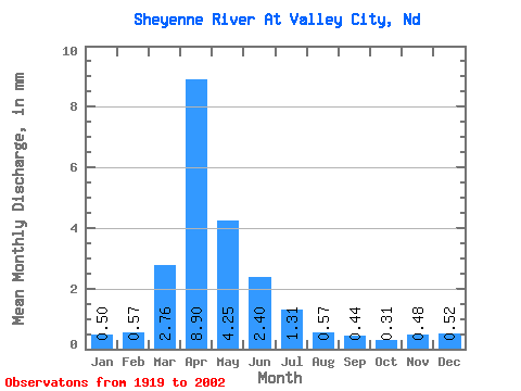
| Statistic | Jan | Feb | Mar | Apr | May | Jun | Jul | Aug | Sep | Oct | Nov | Dec | Annual |
|---|---|---|---|---|---|---|---|---|---|---|---|---|---|
| Mean | 0.14 | 0.15 | 0.74 | 2.41 | 1.15 | 0.65 | 0.35 | 0.15 | 0.12 | 0.09 | 0.13 | 0.14 | 5.41 |
| Standard Deviation | 0.11 | 0.18 | 1.26 | 2.64 | 1.93 | 0.75 | 0.31 | 0.21 | 0.20 | 0.09 | 0.12 | 0.12 | 4.62 |
| Min | 0.00 | 0.00 | 0.00 | 0.01 | 0.04 | 0.03 | 0.00 | 0.00 | 0.00 | 0.00 | 0.00 | 0.00 | 0.81 |
| Max | 0.45 | 0.71 | 6.64 | 10.82 | 11.15 | 4.47 | 0.95 | 1.09 | 1.05 | 0.43 | 0.48 | 0.58 | 23.72 |
| Coefficient of Variation | 0.85 | 1.14 | 1.69 | 1.10 | 1.68 | 1.16 | 0.88 | 1.40 | 1.64 | 1.11 | 0.89 | 0.87 | 0.85 |
 Return to R-Arctic Net Home Page