|
|
|||||||||||||||||
| Point ID: 9657 | Downloads | Plots | Site Data | Code: 05089500 |
|
|
|||||||||||||||||
| Download | |
|---|---|
| Site Descriptor Information | Site Time Series Data |
| Link to all available data | |
| View: | Time Series | All |
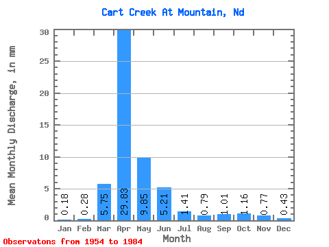
| Units: | m3/s |
| Statistic | Jan | Feb | Mar | Apr | May | Jun | Jul | Aug | Sep | Oct | Nov | Dec | Annual |
|---|---|---|---|---|---|---|---|---|---|---|---|---|---|
| Mean | 0.19 | 0.29 | 5.75 | 29.83 | 9.87 | 5.23 | 1.39 | 0.79 | 1.03 | 1.17 | 0.76 | 0.44 | 58.35 |
| Standard Deviation | 0.34 | 0.69 | 7.87 | 25.11 | 10.11 | 8.12 | 1.49 | 1.40 | 1.89 | 1.65 | 0.74 | 0.85 | 32.86 |
| Min | 0.00 | 0.00 | 0.00 | 1.57 | 0.51 | 0.02 | 0.00 | 0.00 | 0.00 | 0.00 | 0.00 | 0.00 | 5.84 |
| Max | 1.18 | 2.67 | 34.21 | 93.17 | 36.38 | 42.81 | 5.56 | 5.85 | 9.04 | 7.28 | 3.52 | 4.40 | 124.86 |
| Coefficient of Variation | 1.84 | 2.33 | 1.37 | 0.84 | 1.02 | 1.55 | 1.07 | 1.77 | 1.83 | 1.41 | 0.97 | 1.92 | 0.56 |
 Return to R-Arctic Net Home Page