|
|
|||||||||||||||||
| Point ID: 9656 | Downloads | Plots | Site Data | Code: 05099400 |
|
|
|||||||||||||||||
| Download | |
|---|---|
| Site Descriptor Information | Site Time Series Data |
| Link to all available data | |
| View: | Time Series | All |
| Units: | m3/s |
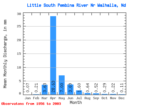
| Statistic | Jan | Feb | Mar | Apr | May | Jun | Jul | Aug | Sep | Oct | Nov | Dec | Annual |
|---|---|---|---|---|---|---|---|---|---|---|---|---|---|
| Mean | 0.06 | 0.20 | 3.42 | 27.05 | 6.62 | 3.49 | 1.51 | 0.60 | 0.49 | 0.28 | 0.20 | 0.11 | 41.82 |
| Standard Deviation | 0.05 | 0.83 | 5.22 | 25.85 | 9.14 | 5.24 | 2.39 | 0.91 | 0.79 | 0.24 | 0.15 | 0.07 | 33.64 |
| Min | 0.00 | 0.00 | 0.00 | 0.77 | 0.38 | 0.07 | 0.03 | 0.00 | 0.01 | 0.03 | 0.03 | 0.01 | 2.71 |
| Max | 0.17 | 4.42 | 22.36 | 71.77 | 41.04 | 25.29 | 10.07 | 3.71 | 3.22 | 0.88 | 0.61 | 0.35 | 120.14 |
| Coefficient of Variation | 0.78 | 4.07 | 1.52 | 0.95 | 1.38 | 1.50 | 1.58 | 1.50 | 1.62 | 0.86 | 0.74 | 0.69 | 0.80 |
 Return to R-Arctic Net Home Page