|
|
|||||||||||||||||
| Point ID: 9654 | Downloads | Plots | Site Data | Code: 05051522 |
|
|
|||||||||||||||||
| Download | |
|---|---|
| Site Descriptor Information | Site Time Series Data |
| Link to all available data | |
| View: | Time Series | All |
| Units: | m3/s |
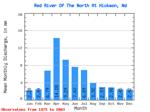
| Statistic | Jan | Feb | Mar | Apr | May | Jun | Jul | Aug | Sep | Oct | Nov | Dec | Annual |
|---|---|---|---|---|---|---|---|---|---|---|---|---|---|
| Mean | 2.28 | 2.46 | 6.79 | 14.28 | 9.29 | 7.60 | 6.89 | 3.92 | 2.97 | 2.90 | 2.45 | 2.42 | 64.74 |
| Standard Deviation | 1.40 | 1.50 | 4.27 | 14.30 | 7.15 | 5.10 | 4.91 | 3.46 | 3.10 | 2.44 | 1.71 | 1.68 | 38.96 |
| Min | 0.03 | 0.09 | 0.52 | 1.09 | 0.15 | 0.57 | 0.50 | 0.24 | 0.08 | 0.01 | 0.00 | 0.00 | 10.54 |
| Max | 5.08 | 6.56 | 18.30 | 65.01 | 26.73 | 21.51 | 18.20 | 18.21 | 14.07 | 10.61 | 5.93 | 6.35 | 143.65 |
| Coefficient of Variation | 0.61 | 0.61 | 0.63 | 1.00 | 0.77 | 0.67 | 0.71 | 0.88 | 1.04 | 0.84 | 0.70 | 0.69 | 0.60 |
 Return to R-Arctic Net Home Page