|
|
|||||||||||||||||
| Point ID: 9650 | Downloads | Plots | Site Data | Code: 05030500 |
|
|
|||||||||||||||||
| Download | |
|---|---|
| Site Descriptor Information | Site Time Series Data |
| Link to all available data | |
| View: | Time Series | All |
| Units: | m3/s |
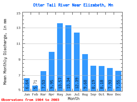
| Statistic | Jan | Feb | Mar | Apr | May | Jun | Jul | Aug | Sep | Oct | Nov | Dec | Annual |
|---|---|---|---|---|---|---|---|---|---|---|---|---|---|
| Mean | 6.64 | 5.76 | 7.53 | 9.95 | 13.57 | 13.34 | 12.38 | 9.67 | 8.20 | 8.17 | 7.93 | 7.55 | 113.85 |
| Standard Deviation | 2.50 | 2.41 | 3.12 | 3.70 | 5.31 | 5.05 | 5.07 | 4.74 | 4.83 | 4.37 | 3.55 | 2.83 | 35.85 |
| Min | 1.90 | 1.52 | 1.67 | 4.14 | 5.26 | 3.88 | 2.57 | 1.54 | 0.75 | 1.15 | 1.83 | 1.90 | 39.09 |
| Max | 11.41 | 11.35 | 15.47 | 16.70 | 25.14 | 23.11 | 22.18 | 18.56 | 18.82 | 17.62 | 15.86 | 12.59 | 175.40 |
| Coefficient of Variation | 0.38 | 0.42 | 0.41 | 0.37 | 0.39 | 0.38 | 0.41 | 0.49 | 0.59 | 0.54 | 0.45 | 0.38 | 0.32 |
 Return to R-Arctic Net Home Page