|
|
|||||||||||||||||
| Point ID: 9649 | Downloads | Plots | Site Data | Code: 05129115 |
|
|
|||||||||||||||||
| Download | |
|---|---|
| Site Descriptor Information | Site Time Series Data |
| Link to all available data | |
| View: | Time Series | All |
| Units: | m3/s |
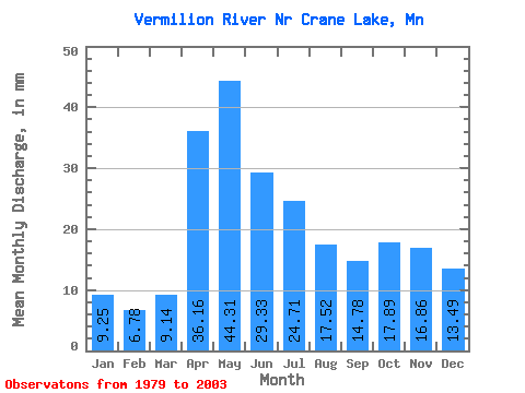
| Statistic | Jan | Feb | Mar | Apr | May | Jun | Jul | Aug | Sep | Oct | Nov | Dec | Annual |
|---|---|---|---|---|---|---|---|---|---|---|---|---|---|
| Mean | 9.25 | 6.84 | 9.14 | 36.16 | 44.30 | 29.33 | 24.71 | 17.51 | 14.78 | 17.89 | 16.86 | 13.49 | 246.40 |
| Standard Deviation | 4.16 | 2.62 | 3.54 | 14.96 | 22.70 | 16.13 | 14.07 | 16.48 | 12.49 | 11.89 | 9.01 | 7.41 | 76.71 |
| Min | 2.73 | 1.88 | 2.90 | 9.22 | 11.75 | 6.42 | 3.64 | 1.94 | 2.16 | 3.55 | 4.14 | 3.44 | 127.10 |
| Max | 15.39 | 11.02 | 18.58 | 71.59 | 97.44 | 69.96 | 52.04 | 72.00 | 58.87 | 46.46 | 35.64 | 28.22 | 449.51 |
| Coefficient of Variation | 0.45 | 0.38 | 0.39 | 0.41 | 0.51 | 0.55 | 0.57 | 0.94 | 0.84 | 0.67 | 0.53 | 0.55 | 0.31 |
 Return to R-Arctic Net Home Page